BMP Effectiveness Study
The North Carolina Forest Service (NCFS) has been awarded US EPA 319 grant funding to examine the effectiveness of forestry Best Management Practices (BMPs) for protecting water quality. The NCFS will partner with the Eastern Forest Environmental Threat Assessment Center to utilize their skills for data collection, analysis and modeling. Research will be conducted on several sites including the NCSU Hill Demonstration Forest and the NC Department of Agriculture and Consumer Services Umstead Research Farm.
Why study BMP effectiveness?
- The Clean Water Act mandates states to develop a protection program for non-point source pollution (Section 208).
- Forestry Best Management Practices (BMPs) are considered to be an effective tool for minimizing the impact of forestry operations on water quality.
- Effectiveness of BMPs are constantly under scrutiny and more research is needed to quantify their benefit to water quality and to determine which specific practices are best suited to do so.
- Previous studies have shown that properly installed BMPs are effective to protect water quality during forestry activities. However, few of these studies were done in the piedmont region of the southeast.
What specific practices will be examined by this study?
- Effectiveness of Neuse and Tar-Pamlico River Basin Riparian Management Rule ("Neuse Buffer Rule") - Two of North Carolina's 17 river basins have rules that mandate width and management of riparian buffer zones along certain streams and water bodies. These buffers will be compared to conventional buffers as specified in NC's Forestry BMP Manual.
- Effectiveness of bridgemats as a tool for reducing the impact of stream crossings on water quality - The NCFS advocates use of bridgemats as the preferred way for crossing streams. NCFS's Bridgemat Loan Program has provided mats for over 170 stream crossings since 2000. Bridgemats will be compared to other crossing methods to determine the benefit to water quality provided by the use of bridgemats.
How will you determine if these practices are effective?
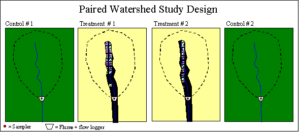
The study plan is to monitor four small, forested headwater streams for two years to establish baseline data. This will help to determine relationships between streams and characterize how those streams react to annual differences in the weather. At the end of that baseline period, two of the watersheds will be harvested and two will remain forested. The forested or "reference" watersheds will then be compared to the harvested or "treatment" watersheds to determine what effects the upland timber harvesting may have on stream flow or water quality. In addition, stream crossing methods will be examined on multiple sites in the piedmont. Measurements will be taken above and below each crossing to determine what effects the crossing has on water quality.
What will be measured?
| Data Category | Parameters | Measurement Frequency | Methods | ||||
|---|---|---|---|---|---|---|---|
| Meteorology | Rainfall, air temperature, relative humidity, total solar radiation, wind speed | Half an hour except rainfall (15 minutes) | Standard micrometeorological station | ||||
| Streamflow | Water depth, flow velocity, flow volume | 15 minutes | Weirs or flumes and associated water level recorders; periodic measurement of flow velocity at different stage heights | ||||
| Soil | Soil moisture release curve, soil porosity, bulk density | Once for pre-harvest and post-harvest | Soil analysis manual | ||||
| Soil erosion and sediment on hillslopes | Survey every two months | Record soil erosion locations with GPS, sediment travel distance; record SMZ breakthrough locations | |||||
| Vegetation | SMZ groundcover, tree density survey, aerial photos | Once | Field survey by USDA Forest Service FIA plot protocols | ||||
| Land topography | Digital Elevation Model (DEM | Once | USGS DEM 30m or 10m database | ||||
| Water quality | Total suspended sediment (TSS), N-NO3, N-NH4 at the watershed outlets | During storm flow at 15 minute intervals | Sigma sampler programmed for storm event sampling | ||||
| Stream water temperature, DO, turbidity, conductance | Weekly in-situ | Automatic meters | |||||
| Stream channels | Channel geomorphology, erosion and dynamics | After every major storm event | Stream channel survey |
Expected products from the study:
- Evaluation of North Carolina's voluntary BMPs and mandatory buffer rules.
- Evaluation of bridgemats as a tool for protecting water quality.
- Addition to the knowledge base to compliment other BMP studies in the southeast.
- Peer reviewed publications.
- Education / demonstration through site visits and tours.