Types of Water Resources Common to Forestry
It is important to understand what kind of stream or other surface water is on-site whenever forestry activities are planned or conducted. Applying the wrong stream classification may result in compliance issues related to FPGs, stream/ditch obstruction laws and/or DWQ Riparian Buffer Rules.
Protection of Streams and Waterbodies
Intermittent and perennial waterbodies, such as ponds or lakes, must be treated with the same protection as streams when complying with the FPGs and DWQ Riparian Buffer Rules. In the FPGs, a "waterbody" is a natural or man-made basin that stores water, but does not include jurisdictional wetlands or beaver ponds.
Stream Classifications for FPG Compliance
The FPGs define a stream as "a body of concentrated flowing water in a natural low area of the land surface" (02 NCAC 60C .0100-.0209). The FPGs further define three types of streams as follows.
Ephemeral Stream
An ephemeral stream is defined as "a stream that flows only during and for short periods following precipitation and flows in low areas that may or may not have a well-defined channel." Some common names for ephemeral streams include: drain, swale, gully, slough (pronounced 'slew') or hollow. Ephemeral streams do not require a SMZ. However, it is strongly encouraged that skid trails, roads, site-prep and other soil-disturbing activities be minimized in the ephemeral streams to avoid erosion and sedimentation of runoff that can flow from the ephemeral into other streams or waterbodies.
Intermittent Stream
An intermittent stream is defined as "a stream that flows only during wet periods of the year (30% - 90% of the time) and flows in a continuous well-defined channel." During dry periods, especially in spring and summer months, intermittent streams may appear as only a trickle of water or may seem to be totally dry, when in fact there is water retained within the stream bottom or "stream substrate". This water retention below the soil surface is usually caused by seasonal changes of the local water table.
Perennial Stream
Perennial streams are streams "that flow throughout a majority of the year (greater than 90% of the time) and flow in a well-defined channel." However, perennial streams can still appear to 'dry up', particularly during extended periods of drought. Therefore, when determining what type of stream you have, it is important to check appropriate maps and seek assistance from a professional.
Stream Classifications for the DWQ Riverbasin & Watershed Riparian Buffer Rules
The way that streams are defined under these various Riparian Buffer Rules is different from the way streams are defined under the North Carolina FPGs. In those areas of the state where these Buffer Rules apply, you should be familiar with how streams and waterbodies are defined so that you can remain in compliance with these Riparian Buffer Rules. Beaver ponds may require you to apply the Riparian Buffer Rule -- Seek professional assistance if you are unsure. The NCFS's Forestry Leaflets series explains how forestry operations must comply with each of these sets of rules.
Types of Maps to Use for Stream Classification
There are two different types of official maps that are used to locate streams. The N.C. Division of Water Resources (DWQ) also uses these two maps for stream classifications related to the Riparian Buffer Rules.
US Geological Survey (USGS) Topographic ("topo") maps at the 1:24000 scale. These are also known as the "7.5 Minute Series". An on-line version of USGS 1:24000 topographic maps can be viewed at TopoZone.com [Note: When you access Topozone's NC map products, use the 1:25000 metric icon; these maps are actually 1:24000 scale. The USGS has not yet completed conversion of NC maps to the metric scale]. These USGS maps can also be obtained through the USGS MAPFINDER or the North Carolina Geological Survey weblinks.
USDA Natural Resources Conservation Service (NRCS) county soil survey maps. This agency used to be called the Soil Conservation Service (SCS). North Carolina's county soil mapbooks are commonly available free of charge at the Cooperative Extension Service or Soil & Water Conservation offices in your county. They can also be obtained from the NRCS offices located across North Carolina.
Determining Stream Types for Riparian Buffer Rules
If a question arises as to whether or not a Riparian Buffer Rule should be applied to a specific channel, stream, or waterbody on your property, you can request an official "stream determination" be made by a certified professional. The NCFS has several foresters across the state that are certified to make these determinations for forestry-related activities only. This determination process involves the use of a detailed multi-step field evaluation form and scoring system.
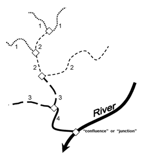
Sample of Strahler (1952) Stream Order Classification System
Stream Order Classification
Streams can be classified into general categories according to their relative size and water flow volume. Strahler (1952) developed the most widely accepted stream order classification system used for forestry applications. In the Strahler system, streams are numbered, with the smaller streams getting a smaller number and larger streams getting a larger number. Usually stream orders range from 1 to 4 using this system. The smaller streams (lower order) are the ones that exist within the upper reaches of a watershed, and are the most common stream orders found on forestry activities. While this ordering system does not apply or effect the regulations for SMZ's or Riparian Buffer Rules, it an interesting lesson in recognizing the natural world around you and appreciating its complexity.