BMP Demonstration Trails
 BMP Demonstration Trail Sign
Trying to explain how to implement Best Management Practices (BMPs) on forestry operations can be challenging without the help of good visual aids. Showing good examples of BMPs on-the-ground can go a long way towards understanding the concept of BMPs.
With this in mind, we have established self-guided, interpretative BMP demonstration trails at several of our state forests;
- Clemmons Educational State Forest near Clayton;
- DuPont State Forest near Brevard;
- Jordan Lake Educational State Forest near Apex; and,
- Mountain Island Lake Educational State Forest near Mt. Holly.
These demonstration areas show real-world examples of everyday BMPs that are appropriate for forestry activities. In forestry, the use of BMPs focuses on the protection of water quality, usually through soil erosion and conservation practices.
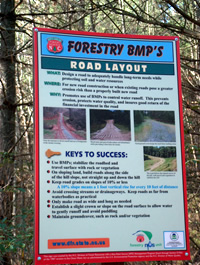
Each demonstration area has several BMP stations, in which a specific BMP application has been installed. At each station there is a sign explaining:
- what the BMP is;
- where the BMP can be effectively used;
- why the BMP is important to use; and
- tips for successful BMP installation.
The demonstration trails showcase a number of BMPs, including:
Broad based dip
Cross drain
Culvert stream crossing
Daylighting
Erosion control mat
Ford stream crossing
Geotextile
Gravel
Road layout
Rock check dam
Sediment pit / silt trap
Silt fence
Site rehabilitation and stabilization
Streamside management zone (SMZ)
Turnout or wing ditch
Waterbar
A brochure is available at each demonstration trail to further explain how BMPs can be used during forestry work to protect water quality.
This project was funded by a U.S. EPA Nonpoint Source Management Program 319-Grant.