NCFS - Home >> Fire
Control & Prevention >> Wildfire/Emergency Response Situation Report
Wildfire/Emergency Response Situation Report
Careless debris burning is the leading cause of wildfires in North Carolina. Don't be careless. Be ready. For prevention tips, visit our Fire Safety Outdoors page.
See the North Carolina Wildfire Public Viewer for current information on North Carolina’s reported and active wildfires.See all fires that have been contolled since January 1, 2023. The map displays all fires that have been entered into the N.C. Forest Service fire record system.
Current situation as of {{month}} {{today}}, {{year}} at {{time}}
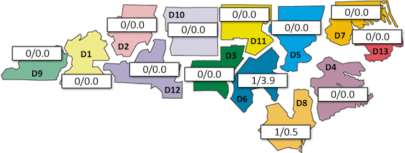
Daily Wildfire Occurrence by district for {{yesterdayMonth}} {{ydate}}, {{year}}.

Preliminary reports show that {{yesterdayFire}} wildfires burned {{yesterdayAcres}} acres on private and state-owned land
in N.C. on {{yday}} {{yesterdayMonth}} {{ydate}}, {{year}}.
Current Wildfire Information
The North Carolina Forest Service tracks daily fire activity using a database known as the "Signal 14". The data from the Signal 14 is a rapid approximation of wildfire occurrence. It's not an exact count. This information does not include uncontained fires or fires that occur on federal property. The information below comes from Signal 14 reports.Period | # Fires | # Acres |
---|---|---|
{{yesterdayMonth}} {{ydate}}, {{year}} | {{yesterdayFire}} | {{yesterdayAcres}} |
Month to date | {{fireMTD}} | {{acreMTD}} |
Year to date | {{fireYTD}} | {{acreYTD}} |
Additional data: Daily Fire Occurrence Summary (PDF) |
Monthly Fire Summary Graph
To change graph input select a radio button and then hit arrow
Show Fires Show Acres
Monthly Fire Summary for {{month}} {{year}}
Date | # Fires | # Acres |
---|---|---|
{{i}} | {{ this["f" + i] }} | {{ this["a" + i] }} |
Date | # Fires | # Acres |
---|---|---|
{{i}} | {{ this["f" + i] }} | {{ this["a" + i] }} |
Month to date | {{fireMTD}} | {{acreMTD}} |
In-state incidents
Incident: Locust Cove Fire #2
Location: McDowell County
Estimated Size: 150-200 acres
Containment: 10%
Number of Personnel Assigned: 80+
Unified Command: U.S. Forest Service and N.C. Forest Service
Summary: The Locust Cove #2 Fire is now estimated at 150-200 acres. The fire is burning near Highway 80 in the Sunnyvale area of McDowell County. Containment is at 10%. The fire began on Nov. 29 within the fire scar of the Locust Cove wildfire (March 2023). Rain and increased humidity have kept fire activity and intensity low. The U.S. Forest Service and N.C. Forest Service have established a unified command in close coordination with McDowell County Emergency Management.
Firefighting efforts yesterday were focused on slowing the head of the fire and protecting private property. Burnout operations were successful in securing the area around private homes and preventing the fire from moving onto private lands. Today, the fire is moving westward into the National Forest and firefighters are working to establish containment lines. More than 80 firefighters are responding and will continue to prioritize securing homes and private property. No structures have been damaged or lost to date.
Smoke from Locust Cove #2 and the Clear Creek Fire is drifting throughout the area. Travelers in the Highway 80 corridor (locally known as Buck Creek Road), should proceed with caution, particularly in the evenings and mornings when smoke may settle.
Latest Fire Information Update
-
Updated 12/1/2023 at 12:49 p.m.
Incident: Clear Creek Fire
Location: McDowell County
Estimated Size: ~124 acres
Containment: 0%
Number of Personnel Assigned: 90
Summary: Firefighters from the U.S. Forest Service, the N.C. Forest Service, Pleasant Gardens Volunteer Fire Department, and McDowell County Emergency Management are responding to a 2nd fire on the Grandfather Ranger District in Pisgah National Forest. The Clear Creek Fire is burning near Highway 80, south of Lake Tahoma, in McDowell County. A drone using Infrared imaging estimated the fire at 124 acres. Containment is at 0%.
The fire began on private land on Nov. 30th. It is burning about 2 miles south of the Locust Cove #2 Fire, which is also burning on U.S. Forest Service land. 90 Firefighters are currently responding to the Clear Creek fire. Firefighting efforts are focused on structure and point protection and securing perimeters around private properties.
Smoke from Locust Cove #2 and the Clear Creek Fire is drifting throughout the area. Travelers in the Highway 80 corridor (locally known as Buck Creek Road), should proceed with caution, particularly in the evenings and mornings when smoke may settle.
Latest Fire Information Update
-
Updated 12/1/2023 at 12:49 p.m.