Stream Restoration
Stream restoration or enhancement activities can achieve many objectives:
- Control severe stream bank erosion and instability
- Repair damage from floods
- Improve aquatic habitat or riparian forest conditions
- Compensate for impacts that result from highway projects or other site development
Forest landowners may benefit from stream or wetland restoration work that is completed on their property. However, these types of projects can be expensive and will require substantial planning, permitting, and engineering expertise. Landowners should inquire with their County Soil & Water Conservation District, or the N.C. Division of Mitigation Services if they wish to learn more about stream restoration opportunities.
Since 2006, the NC Forest Service (NCFS) has hosted and facilitated stream restoration projects upon lands which we are responsible for managing as part of our mission to sustainably manage the multiple resources of our state's forests. In all cases, the funds to pay for our stream restoration projects have been provided by state and federal grants that were obtained specifically for each project. We have partnered with neighboring landowners, agencies, private experts, and N.C. State University to complete the following stream restoration projects:
Purlear Creek, Wilkes County
(Note: This tract of land is now part of the State Parks system as a satellite annex of Stone Mountain State Park and is no longer operating under the management of the N.C. Forest Service.)
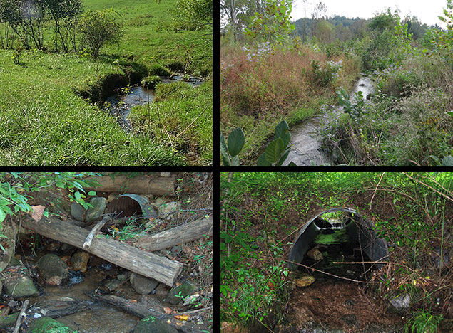
The Results: Approximately 4,100 feet of perennial stream and 1 acre of wetland were restored or enhanced.
The Problem: Prior to ownership by the NCFS, this property was a hay pasture and there was no streamside tree buffer along Purlear Creek. As a result, the stream banks were collapsing and becoming entrenched. The stream was functioning more as a ditch than a natural stream.
The Solution: Segments of a new stream channel were created to relocate the stream into its natural floodplain area. The banks along the existing stream were sloped-back to allow the stream to interact naturally with its floodplain. Thousands of tree seedlings were planted along both sides of the restored stream. We hope that our restoration work is sufficient to support introduction of trout in the future.
Hooker Falls / Little River, Transylvania County, DuPont State Recreational Forest
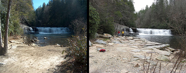
The Results: Approximately 500 feet of river bank along the Little River, above and below Hooker Falls, was re-established, reinforced and stabilized.
The Problem:Years of intense flooding coupled with compacted soil along the river bank due to pedestrian use from forest visitors had allowed large portions of the river bank to wash away. Permanently closing this area to visitors was not a viable option.
The Solution: Large boulders were installed to absorb the impact of flood water and reestablish a firm river bank for visitor access. A few hundred tree seedlings were planted to reestablish vegetation and focus pedestrian traffic.
Reasonover Creek / Lake Julia Outfall, Transylvania County, DuPont State Recreational Forest
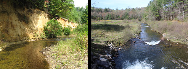
The Results: Approximately 600 feet of perennial stream was re-located and restored.
The Problem: A segment of this creek was rerouted by the previous property owner when Lake Julia was created in the 1950s. Over time, this stream segment had undercut a 30-foot high, bare soil embankment which was rapidly collapsing and dropping excessive sediment into the stream. If left unchecked, the eroding embankment may undermine a road bridge and continue to add sediment into the stream.
The Solution: A new stream channel was established further away from the eroding soil embankment. Water control structures were installed in the new channel, using boulders and large logs. These structures will absorb the impact of flood water and stabilize the stream's structure. Several hundred tree seedlings have been planted and are growing into a new floodplain forest.
- Restoration and Stabilization along Lake Julia Outfall (PDF)
- NCSU Final Project Report (PDF)
- NCFS Supplemental Project Report (PDF)
- 2012 Annual Monitoring Report (PDF)
- 2013 Annual Monitoring Report (PDF)
- 2014 Annual Monitoring Report (PDF)
- 2015 Annual Monitoring Report (PDF)
- 2016 Annual Monitoring Report (PDF)
Linville River Restoration, Avery County, Gill State Forest
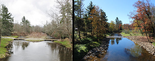
The Results: Approximately 2,000 feet of river was re-configured and restored with new habitat structures; and 400 feet of a tributary stream was enhanced with new vegetation.
The Problem: This section of river was degraded due to excessive sedimentation from bank erosion. The river was disconnected from its floodplain. Also, the fishery habitat was not as good as it could be due to historical river channelization and over-widening.
The Solution: First, an obsolete low-profile bridge was removed. A new limited-access, gravel ford crossing was installed for possible use by the N.C. Forest Service’s wide-dimensional heavy equipment for wildfire control and Linville River Nursery. Then, the river channel was narrowed, and the banks were sloped-back. This allows improved connection between the river and its floodplains during high-water flows. Boulders and logs were strategically installed in the river to improve the habitat and manage the river current’s flow path. Small areas of old river channel were blocked-off to create pools for amphibians. Thousands of trees were installed along the restored river banks and a section of a tributary stream.
Visitors and fishermen: Please stay on designated pathways along the restored river. Avoid tripping over the live-stakes and planted seedlings, and do not pull them up.
- November 2019 Project Update Presentation
- September 2019 Project Update Presentation
- Community Meeting Presentation
- NCDWR Biomonitoring Report (September 2021)